Special Collections
South Central Plains
This EPA Level III ecoregion encompasses all or part of 42 Texas counties. It extends from the Western Gulf Coastal Plain east across much of Louisiana and north into southeastern Oklahoma and southwestern Arkansas. In Texas, it covers approximately the same land area as the Texas Parks & Wildlife Department�s Pineywoods vegetative region. This collection lists only those taxa found in the Texas portion of the South Central Plains ecoregion.Printer Friendly: Species List | List with Images | List with QR Tags to Mobile
| scientific name | common name(s) | image gallery |
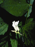
| Amphicarpaea bracteata | American Hogpeanut | |
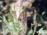
| Amorpha canescens | Leadplant Leadplant Amorpha Prairie Shoestring | |
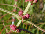
| Ammannia coccinea | Valley Redstem Scarlet Tooth-cup | |
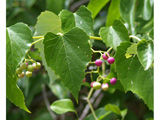
| Ampelopsis cordata | Heartleaf Peppervine Heart-leaf Ampelopsis | |
| Ambrosia confertiflora | Weakleaf Bur Ragweed Weak Leaved Burweed Slimleaf Bursage | |
| Amphiachyris dracunculoides | Prairie Broomweed Broomweed | |
| Amorpha fruticosa | Indigo Bush False Indigo Bush False Indigo Desert False Indigo | |
| Amaranthus greggii | Gregg's Amaranth | |
| Amaranthus hybridus | Slim Amaranth | |
| Amsonia illustris | Ozark Bluestar Showy Blue-star Missouri Blue Star Swamp Bluestar | |
| scientific name | common name(s) | image gallery |